ORANGE BEACH, Ala. — Hurricane Sally drifted in a slow crawl Tuesday toward the northern Gulf Coast, threatening dangerous storm surge and relentless rainfall that forecasters warned could trigger historic flooding as the storm was expected to hover in the area long after coming ashore.
“It’s going to be a huge rainmaker,” Phil Klotzbach, a research scientist and meteorologist at Colorado State University. “It’s not going to be pretty.”
The National Hurricane Center expects Sally to remain a Category 1 hurricane, with top sustained winds of 80 mph (130 kph) when it makes landfall late Tuesday or early Wednesday. The storm’s sluggish pace made it harder to predict exactly where its center will strike, though it was expected to reach land near the Mississippi-Alabama state line.
By late morning Tuesday, hurricane warnings stretched from east of Bay St. Louis, Mississippi, to Navarre, Florida. Rainfall of up to 20 inches (50 centimeters) was forecast near the coast. There was a chance the storm could also spawn tornadoes and dump isolated rain accumulations of 30 inches (76 centimeters).
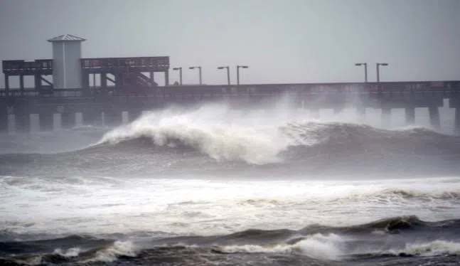
In Orange Beach, Alabama, towering waves crashed onshore Tuesday as Crystal Smith and her young daughter, Taylor, watched. They drove more than an hour through sheets of rain and whipping wind to take in the sight.
“It’s beautiful, I love it,” Crystal Smith said. “But they are high. Hardly any of the beach isn’t covered.”
Capt. Michael Thomas, an Orange Beach fishing guide, was outside securing boats and making other last-minute preparations. He estimated up to 5 inches (13 centimeters) of rain had fallen in as many hours.
“I’m as prepared as I can be,” Thomas said.
A couple miles away in Gulf Shores, Alabama, waves crashed over the end of the long fishing pier at Gulf State Park. Some roads in the town already were covered with water.
Stacy Stewart, a senior specialist with the National Hurricane Center, said Tuesday that people should continue to take the storm seriously since “devastating” rainfall is expected in large areas. People could drown in the flooding, he said.
“This is going to be historic flooding along with the historic rainfall,” Stewart said. “If people live near rivers, small streams and creeks, they need to evacuate and go somewhere else.”
Donald Jones, a National Weather Service meteorologist in Louisiana, said Sally could unleash flooding similar to what Hurricane Harvey inflicted in 2017 when it swamped the Houston metropolitan area.
Along the I-10 highway that runs parallel to the Gulf Coast from Louisiana to Florida, rain grew heavier Tuesday in places like Gautier and Pascagoula, Mississippi. Businesses along highway exits appeared to be largely closed.
In Gulfport, Mississippi, white plastic bags hung over some gas station pumps to signal they were out of fuel. Along a bayou that extended inland from the Gulf, three shrimp boats were tied up as shrimpers and others tried to protect their boats from waves and storm surge. Most boat slips at Gulfport’s marina were empty, and many businesses had metal storm shutters or plywood covering the windows.
In Alabama, officials closed the causeway to Dauphin Island and the commuter tunnel that runs beneath the Mobile River. An online video from Dauphin Island showed a few cars and SUVs stuck in a beachfront area, their tires sunk deep into wet sand.
Alabama Gov. Kay Ivey urged residents near Mobile Bay and low-lying areas near rivers to evacuate if conditions still permitted a safe escape. The National Hurricane Center predicted storm surge along Alabama’s coast, including Mobile Bay, could reach 7 feet (2.1 meters) above ground.
“This is not worth risking your life,” Ivey said during a news conference Tuesday.
The storm was moving at only 2 mph (4 kph) Tuesday afternoon, centered about 105 miles (165 kilometers) south of Mobile, Alabama, and 60 miles (95 kilometers) east of the mouth of the Mississippi River. Hurricane-force winds stretched 45 miles (75 kilometers) from its center.
Forecasters expected Sally to move slowly northward Tuesday, with the storm’s center bypassing the coast of southeastern Louisiana.
After making landfall, Sally was forecast to cause flash floods and minor to moderate river flooding across inland portions of Mississippi, Alabama, northern Georgia and the western Carolinas through the rest of the week.
Florida Gov. Ron DeSantis declared an emergency in the Panhandle’s westernmost counties, which were being pummeled by rain from Sally’s outer bands early Tuesday. The threat of heavy rain and storm surge was exacerbated by the storm’s slow movement.
President Donald Trump issued emergency declarations for parts of Louisiana, Mississippi and Alabama on Monday, and tweeted that residents should listen to state and local leaders.
The threat to Louisiana was easing as officials in some areas reversed evacuation orders that had been issued for areas that had been feared to be a risk of flooding from Sally. In New Orleans, government offices and public school operations were slated to reopen Wednesday.
The southwestern part of the state was pummeled by Hurricane Laura on Aug. 27 and an estimated 2,000 evacuees from that storm were sheltered in New Orleans, mostly in hotels.
Monday marked only the second time on record, forecasters said, that five tropical cyclones swirled simultaneously in the Atlantic basin. The last time that happened was in 1971. None of the others were expected to threaten the U.S. this week, if at all. One was downgraded to a low-pressure trough Monday evening.
The extraordinarily busy hurricane season — like the catastrophic wildfire season on the West Coast — has focused attention on the role of climate change.
Scientists say global warming is making the strongest of hurricanes, those with wind speeds of 110 mph or more, even stronger. Also, warmer air holds more moisture, making storms rainier, and rising seas from global warming make storm surges higher and more damaging.
In addition, scientists have been seeing tropical storms and hurricanes slow down once they hit the United States by about 17% since 1900, and that gives them the opportunity to unload more rain over one place, as 2017’s Hurricane Harvey did in Houston.
Copyright 2020 The Associated Press. All Rights Reserved. This material may not be published, broadcast, rewritten, or redistributed. PHOTO: AP


")


